Q1. What is the other name of the highest range in the Western Ghats?
(a) Pir Panjal
(b) Siwalik range
(c) Sahyadris
(d) Namcha Barwa
Answer: (c)
Explanation: The Western Ghats, also known as Sahyadri (Benevolent Mountains), are a mountain range that covers an area of 140,000 square kilometres (54,000 sq. mi) in a stretch of 1,600 kilometres (990 mi) parallel to the western coast of the Indian peninsula, traversing the states of Tamil Nadu, Kerala, Karnataka, Goa, Maharashtra and Gujarat. It is a UNESCO World Heritage Site.
Q2. Which state has the longest coastline?
(a) Andhra Pradesh
(b) Maharashtra
(c) Gujarat
(d) Karnataka
Answer: (c)
Explanation:Gujarat has the longest coastline in mainland India. Its length is about 1600 km. But if we take all states & UTs, Andaman & Nicobar Islands have the longest coastline in India of about 1962 km.
Q3. . Which one of the following mountain ranges is spread over only one state in India?
(a) Aravalli
(b) Satpura
(c) Ajanta
(d) Sahyadri
Answer: (c)
Explanation: Ajanta mountain range is short-range, which spreads within Maharashtra.
– Aravali ranges cover Rajasthan, Haryana and Delhi
– Satpura ranges are found in Gujrat and Madhya Pradesh.
– Sahyadris ranges start from Gujrat, Maharastra border and crossing Goa, Karnataka it reaches Kerala tip up to Cape Comrie.
– Ajanta is found in the Aurangabad district of Maharastra.
Q4. The longest beach in India is situated at
(a) Mumbai
(b) Chennai
(c) Mangalore
(d) Tuticorin
Answer: (b)
Explanation: Marina beach in Chennai along the Bay of Bengal is India’s longest and the world’s second-longest beach. This predominantly sandy of nearly 12 kilometres extends from Beasant Nagar in the south to Fort St. George in the north.
Q5. Which of the following passes lies in the Sutlej valley?
(a) Nathu La
(b) Jelep La
(c) Shipki La
(d) Sharabathanga
Answer: (c)
Explanation: Sutlej River originates from Rakas Lake near Mansarovar Lake and enters the Indian state of Himachal Pradesh through Shipki La Pass.
Q6. The National Highway from Amritsar to Calcutta via Delhi is numbered:
(a) 1
(b) 2
(c) 4
(d) 8
Answer: (b)
Explanation: National Highway from Amritsar to Calcutta via Delhi is called National highway No. 2. It was called Grand Trunk road and was constructed by Sher Shah in the Medieval Period.
Q7. What is the name given to the foothills zone of the Himalayas?
(a) Inner Himalayas
(b) Central Himalayas
(c) Middle Himalayas
(d) Siwalik
Answer: (d)
Explanation: This range of outer (lower) Himalayas is well known as ‘Shivalik Hills‘ (also known as Manak Parbat in ancient times). Shivalik literally means ‘tresses of the Shiva’.
Q8. The pilgrims of Kailash Mansarovar have to pass through which pass to enter Tibet?
(a) Khardungala
(b) Rohtanga
(c) Lipu Lekh
(d) Nathu La
Answer: (c)
Explanation: Lipu lekh pass in Uttarkhand is the way through which pilgrims of Kailash Mansarovar enters Tibet. Although Option (d) can also be considered correct as presently China has opened Nathula pass considering the damage which was done to Lipulekh pass in Uttarakhand floods.
Q9. If it is 10.00 am. I.S.T., then what would be the local time at Shillong on 92° E longitude?
(a) 9.38 a.m.
(b) 10.38 a.m.
(c) 10.22 a.m.
(d) 9.22 a.m.
Answer: (b)
Explanation: Longitude of IST is 82.5 ° E
∴ difference of Longitude = 92 – 82.5 = 9.5°
∴ difference of time = 9.5 × 4 = 38 min
∴ local time at Shillong = 10.38 a.m.
Q10. In which part of India is Dandakaranaya situated?
(a) Northern
(b) Eastern
(c) Central
(d) Western
Answer: (b)
Explanation:Dandakaranya is a historical region in India, mentioned in the Ramayana. It is identified with a territory roughly equivalent to the Bastar division in the Chhattisgarh state in the central-east part of India.
Q11. Which of the following processes is responsible for producing the sand dunes in western Rajasthan?
(a) Wind erosion
(b) Erosion by water
(c) Wind deposition
(d) Mechanical weathering
Answer: (c)
Explanation: Sand dunes are the depositional features that are formed due to the deposition of sand particles carried by the wind. A sand dunes shape depends upon the direction and speed of the wind.
Q12. Which one of the following statements is not true?
(a) Ghaggar’s water is utilized in the Indira Gandhi canal
(b) Narmada rises from Amarkantak region
(c) Nizam Sagar is situated on the Manjra river
(d) Penganga is a tributary of the Godavari
Answer: (a)
Explanation: Indira Gandhi Canal originated from Harike barrage at Sultanpur on Sutlej but Ghaggar is a tributary of river Saraswati, which ends in the Thar Desert.
Q13. The highest peak of south India is
(a) Dodabeta
(b) Anamudi
(c) Mahendragire
(d) Yercaud
Answer: (b)
Explanation: Anamudi is the highest peak in South India. It is situated at an elevation of 2695 metres and is located in Kerala.
Q14. Consider the following statements and select the correct answer by using the codes given below:
Assertion (A): In South India, a semi-arid steppe climate is found in parts of the Karnataka plateau.
Reason (R): It lies in the rain shadow area of Sahyadris.
Codes:
(a) Both A and R are correct and R is the correct explanation of A.
(b) Both A and R are correct, but R is not the correct explanation of A.
(c) A is true, but R is false.
(d) A is false, but R is true.
Answer: (a)
Explanation: Due to the rain shadow area of Sahyadri the regions between Karnataka and Andhra Pradesh have become semi–arid.
Q15. The highest peak in India-
(a) Kamet
(b) Nandakot
(c) Nanda Devi
(d) K2 (Godwin Austin)
Answer: (d)
Explanation:
Top 10 Highest Peaks in India
Mountain Peak
Height
Description
K2
8611 metres
♦ The highest peak in the Indian subcontinent lies between Baltistan and Xinjiang
♦ It is the highest peak in the Karakoram
Kangchenjunga
8586 metres
♦ The third highest summit in the World
♦ Also known as the ‘five treasures of snow’
♦ Lies in Himalayan Mountain Range
Nanda Devi
7816 metres
♦ Ranked the 23rd highest peak across the world.
♦ The Nanda Devi National Prak, located in the vicinity of the peak, consists of the best high altitude flora and fauna.
♦ This is the highest peak located entirely within India
♦ It is a part of Himalayan mountain ranges (Garhwal)
Kamet
7756 metres
♦ It is located near the Tibetan Plateau
♦ It is located in the Garhwal region
Saltoro Kangri
7742 metres
♦ It is located near the Siachen Region.
♦ The Saltoro Kangri is ranked the 31st highest independent peak in the world
♦ It lies in the Saltoro range (a part of Karakoram Mountain range)
Saser Kangri
7672 metres
♦ Located in Ladakh.
♦ This mountain peak is the 35th highest mountain peak in the world
♦ It lies in Saser Muztagh range (an easternmost subrange of Karakoram Range.)
Mamostong Kangri/Mamostang Kangri
7516 metres
♦ It is located near Siachen Glacier
♦ It is the 48th independent peak in India
♦ It is the highest peak of Rimo Muztagh range (a subrange of the Karakoram range)
Rimo I
7385 metres
♦ The Rimo I is a part of Rimo Muztagh, a subrange of Great Karakoram range.
♦ It is the 71st highest peak in the world.
Hardeol
7151 metres
♦ This peak is also known as the ‘Temple of God’ ♦ It is one of the oldest summits in the Kumaon Himalaya
Chaukhamba I
7138 metres
♦ It is located in the Garhwal district of Uttrakhand. ♦ It is a part of the Gangotri Group of Garhwal Himalaya ranges
Trisul I
7120 metres
♦ The name of this mountain peak is taken from the weapon of Lord Shiva. ♦ It is one of three mountain peaks located in the Kumaon Himalaya in Uttrakhand.
Q16. Match List-I with List-II and select the correct answer from the codes given below:
List-I (Hill resorts)
List-II (State)
A. Dalhousie
1. Jammu and Kashmir
B. Darjeeling
2. Himachal Pradesh
C. Mussoorie
3. West Bengal
D. Pahalgam
4. Uttarakhand
Codes: A B C D
(a) 2 4 3 1
(b) 1 3 2 4
(c) 2 3 4 1
(d) 3 1 4 2
Answer: (c)
Explanation:Dalhousie is in Himachal Pradesh, Darjeeling is in West Bengal, Mussoorie is in Uttrakhand and Pahalgam is in Jammu and Kashmir.
Q17. Duncan passage is located between-
(a) South and Little Andaman
(b) North and South Andaman
(c) North and Middle Andaman
(d) Andaman and Nicobar
Answer: (a)
Explanation: Duncan Passage is a strait in the Indian Ocean. It is about 48 km wide; it is located in between South Andaman and Little Andaman.
Q18. Among the following which river flows in a rift valley?
(a) Kaveri
(b) Yamuna
(c) Son
(d) Tapti
Answer: (d)
Explanation:A rift valley is created on a divergent plate boundary by the action of a fault or rift. There is further spreading of crust and subsequent erosion deepens the rift.
Rivers that flow through rift valleys in India are Narmada River, Tapti, Mahi (all flowing west), Damodar River in Chota Nagpur plateau.
Q19. The place Sabarimala is situated in which of the following States?
(a) Andhra Pradesh
(b)Tamil Nadu
(c) Kerala (d) Karnataka
Answer: (c)
Explanation: Sabarimala is a hill situated in Perinad village, Ranni Taluk, Pathanamthitta district in Kerala State. This hill is situated 72 kilometres from Pathanamthitta town.
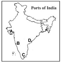
Q20. Match the locations of ports labelled as A, B, C and D in the given map with the names of those ports and select the correct answer using the codes given below the names of the ports:
Kakinada
Karwar
Mangalore
Tuticorin
Veraval
Codes:
(a) A-4; B-2; C-3; D-5
(b) A-5; B-2; C-4; D-1
(c) A-1; B-3; C-4; D-2
(d) A-5; B-3; C-2; D-1
Answer: (b)
Explanation: In the given map ‘A’ marked port is Veraval of Gujarat, ‘B’ marked port is Karwar of Karnataka, ‘C’ marked port is Tuticorin of Tamil Nadu and ‘D’ marked port in Kakinada of Andhra Pradesh.
Q21. Match the dams and the States in which they are situated-
Dam
State
A. Tungabhadra
1. Kerala
B. Lower Bhawani
2. Andhra Pradesh
C. Idukki
3. Tamil Nadu
D. Nagarjuna Sagar
4. Karnataka
Codes: A B C D
(a) 3 2 4 1
(b) 2 4 3 1
(c) 4 3 1 2
(d) 1 4 2 3
Answer: (c)
Explanation:
The Tungabhadra Dam is also known as Pampa Sagar is constructed across the Tungabhadra River, a tributary of the Krishna River. The dam is in Hosapete, Ballari district of Karnataka.
Lower Bhavani Project Canal is a 201-kilometre (125 mi) long irrigation canal which runs in Erode district in Tamil Nadu, India. The canal is a valley-side contour canal, fed by Bhavanisagar Dam and irrigates 2.07 lakh hectares of land.
The Idukki Dam is a double curvature arch dam constructed across the Periyar River in a narrow gorge between two granite hills locally known as Kuravan and Kurathi in Kerala, India. At 168.91 metres, it is one of the highest arch dams in Asia. It is constructed and owned by the Kerala State Electricity Board.
Nagarjuna Sagar Dam is a masonry dam across the Krishna River at Nagarjuna Sagar which straddles the border between Guntur district, Andhra Pradesh and Nalgonda district, Telangana. Constructed between 1955 and 1967, the dam created a water reservoir with a gross storage capacity of 11.472 billion cubic metres.
Q22. Which of the following pairs are correctly matched?
I. Kapildhara Falls—Godavari River
II. Jog Falls—Sharavathi River
III. Shivasamudram Falls—Cauvery River
Select the correct answer using the code given below:
(a) I and II
(b) II and III
(c) I and III
(d) I, II and III
Answer: (b)
Explanation:Kapildhara waterfall is located in the Amarkantak district of the central Indian state of Madhya Pradesh. It lies at a distance of 6 kilometres from the Narmada Kund. The holy waters of the River Narmada plunge from a height of about 100 feet, from the ground level. This cascade gets its name from the famous sage Kapil, who had resided at this place and performed severe religious austerities. Kapil muni is said to have received the divine light at this very place, according to the ancient scriptures. He had also written ‘Sankhya Philosophy’ an advanced treatise on mathematics in the Kapil ashram. divine light at this very place, according to the ancient scriptures. He had also written ‘Sankhya Philosophy’ an advanced treatise on mathematics in the Kapil ashram.
Jog Falls is a waterfall on the Sharavati River located in the Western Ghats in Sagara taluk, Shimoga district. It is the second-highest plunge waterfall in India.
Shivanasamudra Falls is a waterfall in Mandya District of the state of Karnataka, India. It is situated along the Kaveri River, which forms here the boundary to the Mandya, and is the location of one of the first hydro-electric power stations in Asia, which was set up in 1902.
Q23. Match List-I with List-II and select the correct answer using the codes given below the lists:
List-I (National Park/Wildlife Sanctuary)
List-II (State)
A. Bondla Wildlife Sanctuary
1. Orissa
B. Kangerghat National Park
2. Assam
C. Orang Sanctuary
3. Chhattisgarh
D. Ushkothi Wildlife Sanctuary
4. Goa
5. Tripura
Codes:
(a) A-2; B-1; C-5; D-3
(b) A-4; B-3; C-2; D-1
(c) A-2; B-3; C-5; D-1
(d) A-4; B-1; C-2; D-3
Answer: (b)
Explanation: Bondla Wildlife Sanctuary is located in northeastern Goa, India in Ponda taluka. The total area of the park is 8 km2.
Kanger Ghati National Park (also called Kanger Valley National Park) was declared a national park in 1982 by the Government of India. Among the various protected areas in the country, the Kanger Valley National Park near Jagdalpur, in the Bastar region of Chhattisgarh is one of the densest national parks, well known for its biodiversity, landscape, waterfalls, subterranean geomorphologic limestone caves, and home for the Bastar hill myna, the state bird of Chhattisgarh.
The Orang National Park is a national park in India located on the northern bank of the Brahmaputra River in the Darrang and Sonitpur districts of Assam. It covers an area of 78.81 km². It was established as a sanctuary in 1985 and declared a national park on 13 April 1999.
Ushakothi Wildlife Sanctuary – Ushakothi or Badrama Sanctuary in Yavatmal, Odisha (Orissa) has a population of tigers, leopards, panthers, sloth bears and elephants in addition to the sambal, gaur, chital and nilgai. Established in 1962 over a forest area of about 304.03 square kilometres.
Q24. Consider the following statements
Rural forestry aims to raise the trees on community land and on privately owned land.
Farm forestry encourages individual farmers to plant trees on their own farmland to meet the domestic need of the family.
Which of the statement(s) given above is/are correct?
(a) Only 1
(b) Only 2
(c) Both 1 and 2
(d) Neither 1 nor 2
Answer: (c)
Explanation: Rural forestry (also known as community forestry) aims to raise the trees on community land and on privately owned land as in farm forestry.
Farm forestry encouraged individual farmers to plant trees on their own farmland to meet the domestic needs of the family.
All these schemes are taken up under the social forestry programme.
Q25. From North towards South, which one of the following is the correct sequence of the given rivers in India?
(a) Shyok-Spiti-Zaskar- Sutlej
(b) Shyok-Zaskar-Spiti-Sutlej
(c) Zaskar-Shyok-Sutlej- Spiti
(d) Zaskar-Sutlej-Shyok-Spiti
Answer: (b)
Explanation: The correct sequence of the rivers in India from the north towards the south is Shyok – Zaskar – Spiti – Satluj. Shyok flows through northern Ladakh in India. Zaskar River flows in the northeastern part of Ladakh. Spiti River is situated at Kaza in Himachal Pradesh at an elevation of 12500 feet. Satluj river rises from the slopes of Kailash and flows in a south-westerly direction to Himachal Pradesh & Punjab.